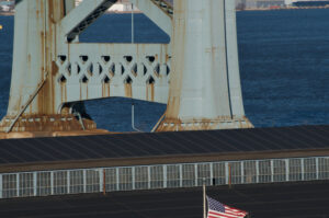
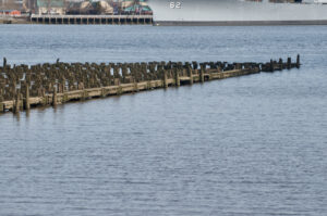
The first image in this somewhat meandering (in the picturesque, river-like sense!) photo-essay depicts the spot—more or less—where over 1,000,000 people first set foot on U.S. soil. It’s at the present tip of what’s known as Pier 53, just over a mile south of my apartment in the city’s historic district. The number 53 suggests something of the scale of the old port of Philadelphia, which consisted of a dense, comb-like network of piers reaching out from Philadelphia’s riverbank into the heavily trafficked waters of the Delaware River.
The tip of Pier 53, Philadelphia PA. Photo © Max Cavitch.
In 1873, during the era of the modern steamship, Pier 53 was converted into the Washington Avenue Immigration Station, where, for over forty years, it was one of the nation’s chief entry-points for émigrés from various European locales, including the four regions—Munster, Cornwall, Derbyshire, and Bryansk—from which all of my various progenitors, at one point or another, came to this country. As far as I know, none of them disembarked at Pier 53. But it’s easy to imagine them doing so; many just like them did, until the station was closed during World War I.
More than a century later, after long decades of disuse and disrepair, it’s remarkable that Pier 53 still exists at all. And the people who disembarked here when it was still an immigration station would likely be very surprised to see it today. It’s been structurally reinforced, richly sodded, and lovingly planted with various species of grasses, shrubs, and trees, and it’s regularly groomed by workers employed by the city, which decided in 2010 to transform this derelict into a public recreation area, now known as “Washington Avenue Park.”
I come here a lot—not for sentimental reasons, but to take photographs of flora and fauna for the public-science project, iNaturalist. For this whole area of riverbank, stretching about nine-tenths of a mile from the Walmart Supercenter to the U.S. Coast Guard Station, is now part of the Delaware River Trail system, a segment-by-segment project that builds foot-and-bike paths through the river’s riparian zone.
“Riparian” comes from the Latin word ripa, or “riverbank.” A riparian zone is a particular kind of terrestrial biome, consisting of the interface between a land-mass and a river. These zones are often rich with living things—particularly with species of hydrophilic flora and fauna, many of which serve important purposes for the river’s natural as well as cultivated worlds. For example, they play significant roles in soil conservation, civil engineering, and resource management, as well as in enhancing biodiversity generally. Riparian zones may include woods, grasslands, wetlands, and non-vegetative areas as well. Some occur naturally, of course; but many are constructed by humans, often for soil stabilization. Riparian zones can act as biofilters, preventing excessive sedimentation, runoff, and erosion, while also providing shelter for aquatic as well as terrestrial animals. Examples of built riparian zones includes the concrete sides of the L.A. River that we’ve all seen in movies, Battery City Park in lower Manhattan, and the levees of New Orleans.
Riparian zones that are particularly well-shaded can help limit sharp fluctuations in both air and water temperature, making them especially hospitable for people and other land animals, as well as for fish and plants. When it comes to reclaiming polluted rivers, like the Delaware, riparian zones are often essential: for example, they can help filter nitrates in surface runoff (like manure and agrochemicals); facilitate carbon transport between ecosystems; help trap sediment, including human trash and waste, which makes for less turbid water; and, for humans and other animals alike, enable easy movement along riverine systems.
Some riparian zones also boost property values: they can prettify views from riverside structures, provide access to foot- and bike-paths, and create opportunities for riparian sports such as fishing, swimming, and boating. Such features lure investors, developers, and would-be residents, and, indeed, many of the Delaware’s riparian zones, including my gentrified neighborhood, are lined with pricey condos, hotels, and restaurants—though these tend to be located further from the river, in what’s called the “setback zone,” to minimize flood risk.
This path along the Pennsylvania side of the Delaware River is still very much a work-in-progress; other, similar segments have been finished, but they have yet to be linked together to form a single, continuous, serpentine trail. (On the other side of town, the Schuylkill River Trail system is far more impressive: most of it is already complete, and, when entirely finished, it will run for 120 miles through five Pennsylvania counties, all the way from Philadelphia to Frackville.)
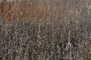
These stretches of unevenly developed land—expanding and shrinking in width, fenced where the distinction between “public” and “private” is deemed especially important to announce, sometimes swerving inland, sometimes veering almost to the water’s edge—can be surprisingly rewarding for amateur naturalists like myself. The one near me is a band of biodiversity, wending its way through an urban mix of residential neighborhoods, post-industrial wastelands, shipyards, military installations, strip-malls, and big-box stores.
Among the species I’ve photographed and ID’d near Pier 53 are: common sunflowers, downy woodpeckers, false bindweeds, plumeless thistles, bumble bees, eastern calligrapher flies, butterfly milkweed, red deadnettles, mallards, American pokeweed, eastern gray squirrels, spotted cucumber beetles, brown-eyed Susans, tiger bee flies, red columbine, common gilled mushrooms, pigweed flea beetles, ovenbirds, pearl crescent butterflies, peppered jumping spiders, wild indigo duskywing butterflies, greenbottle flies, northern mockingbirds, eastern carpenter bees, and, of course, lots and lots of spotted lanternflies.


Life in the riparian zone (clockwise from upper left): an ovenbird, plumeless thistle, a pigweed flea
beetle, and red columbine. All photos © Max Cavitch.
The spotted lanternfly (Lycorma delicatula) is a gorgeous species of planthopper, about an inch long, with diaphanous gray forewings dotted with black spots, crimson hindwings adorned with white and black wedges, and a yellow abdomen with white and black bands. The species is indigenous to Bangladesh, Southern China, Taiwan, and Vietnam, but, in 2014, it was discovered to have migrated to Pennsylvania, where it is considered—like my forebears—supernumerary and undesirable.

Spotted lanternfly, North Front Street, Philadelphia. Photo © Max Cavitch.
Spotted lanternflies do significant damage to native plants and commercial crops such as apples, hops, and hardwoods by causing oozing sap, wilting, leaf-curling, and dieback. They also secrete a sugary “honeydew” that promotes mold growth that’s harmful to other plants (though not to animals). Because they have no natural predators in the mid-Atlantic region, Spotted lanternfly populations have exploded throughout the counties of Southeastern Pennsylvania, including Philadelphia County. When it comes to Spotted lanternflies, the Pennsylvania Department of Agriculture minces no words:
If you see a spotted lanternfly, it’s imperative to immediately report it online or via phone by calling 1-888-4BADFLY. Especially if you are not inside the quarantine zone. What else? Kill it! Squash it, smash it…just get rid of it. In the fall, these bugs will lay egg masses with 30-50 eggs each. These are called bad bugs for a reason, don’t let them take over your county next.
The reason the P.D.A. set up a toll-free number of their own is that police switchboards were being overwhelmed with 911 calls about “sightings” of these “Oriental invaders.” The agricultural damage they do is real, but some of the enthusiasm with which people want to root out these and other “invasives” may also reflect an all-too-common racism.
It’s unclear how Pennsylvania’s spotted lanternfly population might be brought under control—though perhaps the most efficient mechanism would be to find a way to get them all to drink directly from the Delaware River, as its robust cocktail of fecal coliform bacteria, cryptosporidia, arsenic, mercury, PCBs, other industrial pollutants, and random pharmaceuticals, would surely be sufficiently toxic.
In all fairness, the Delaware River is much cleaner than it was in the last century (some of us remember the days when rivers in industrial regions of the U.S. were so polluted that they would actually catch fire). Whereas a couple of decades ago Philadelphians would argue about which river smelled worse, the Schuylkill or the Delaware, now at least some residents will even drink river-sourced tap-water (which is, of course, robustly treated and carefully filtered). In fact, in recognition of the clean-up efforts that have done so much to improve its water-quality, the environmental group, American Rivers, recently named the Delaware “River of the Year for 2020”…but they certainly wouldn’t advise you to let your children swim in it.
Very few of the world’s greatest rivers run that clean. The Nile, the Ganges, the Sarno, the Mississippi, the Jordan, the Yangtze, the Murray, the Indus, and the Danube are all among the most toxic rivers in the world, as the Delaware itself once was. And, like the Delaware, all of these rivers cut right through the urban hearts of some of the world’s most densely populated areas. Regional-pollutant effects vary tremendously, and it makes sense to try to tackle these problems on the local level. Still, all of the world’s riverine waterways are intricately interconnected, via aquifers and oceans, canals and estuaries, evaporation and condensation, tides and tributaries. Cleaning up the Nile and the Mississippi and all of these great rivers should be urgent regional priorities. But to think of them in splendid isolation from one another would be bad science and bad policy.
Contaminated river water is nothing new; large human settlements ensure it. But, in the Delaware for example, the amount and the toxicity of the contaminants have grown exponentially since, over 400 years ago, it was called “Kithanne Whittyuck.” That is, long before George Washington crossed it, and for who knows how many centuries before the Dutch and the Swedes pitched the first European encampments along its lower banks, that’s the name is was called by the Lenape people. Then the Europeans arrived and, being mostly Dutch at first, renamed it “Zuydt [South] Kille” (to distinguish it from the “Noort [North] Kille,” now known as the Hudson). Shortly thereafter, the English kicked out the Dutch and renamed the river after Sir Thomas West, who also happened to be the 3rd Baron De La Warr.
This Baron was the Governor of England’s Virginia Colony, yet he never made it far enough north to see the bay and the river and the entire nation of indigenous people all named, by the British, after him. He’d meant to. But, while convalescing in England, he heard that the man he’d left in charge of Virginia during his absence, Samuel Argall, was tyrannizing over the colonists. So, in 1618, the Baron set sail to investigate. Somewhere between the Old world and the New one, however, the Baron died—poisoned, apparently, by someone loyal to Argall. For four centuries, then, this great river, which descends, in two branches, all the way from the western flank of New York’s Catskill Mountains (Rip Van Winkle country) for just about 418 miles until its waters get to Delaware Bay—where they embouchure into the Atlantic Ocean, passing through the gates of New Jersey’s Cape May in and Delaware’s Cape Henlopen—has been known as the Delaware River.
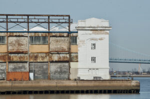
Like millions of other people in Delaware, New York, New Jersey, and Pennsylvania, I live on a bank of the Delaware. My apartment is on Front Street in Philadelphia, which runs north-south, parallel to the river. In 1682, Front Street was the very first street laid out and built in the British colony of Pennsylvania, in keeping with the plan devised by William Penn. It was part of the King’s Highway, which ran all the way from Boston to Charleston, and, for over 200 years, it was the waterfront of the port of Philadelphia, which was the first major shipping port in North America. It remains one of largest and most important to this day, when around a third of the U.S. population lives within a five-hour drive.
I live in an old converted warehouse that used to be much closer to the water. Front Street actually used to “front” the river itself. But, in the mid-1950s, city government launched an ambitious plan to expand the eastern edge of the city into the river, with millions of tons of landfill. Over the next several decades, the new land was graded and built up. Commercial and residential structures, new streets and highways (including a stretch of I-95), parks, monuments, and museums now exist where the river used to flow, including right past my door. Now, I have to climb the stairs to the roof to be able to see the river—or cross several busy thoroughfares to reach its modern edge.
Views of the Delaware from the roof, North Front Street, Philadelphia. All photos © Max Cavitch.
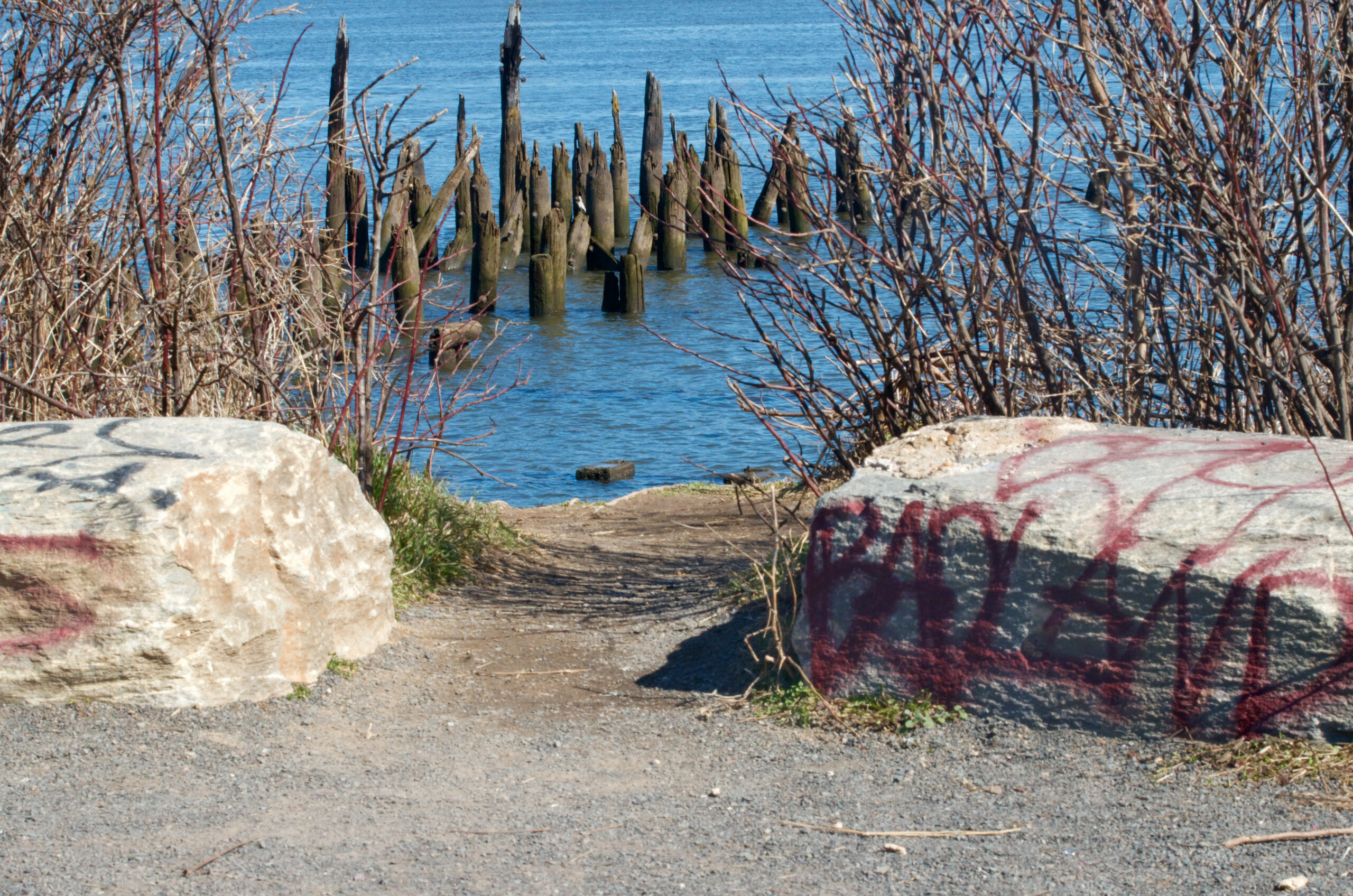
The Washington Avenue Park is less than a mile and a half to the south. When I’m not hunting elusive insects and rare grasses, I like to walk among the relics of the old piers. Where there once were dozens, most have been cleared away. The ones that remain, with one bucolic exception, are mostly half-sunken tangles of wood and iron, overgrown with various trees, shrubs, and wild grasses, which make excellent hide-y-holes for people who want to hook up or do drugs, and where many unhoused people set up transient dwellings.
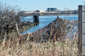
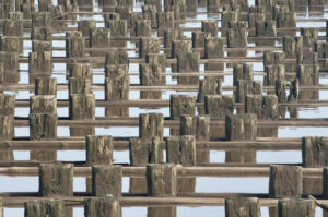
Delaware riverine relics. All photos © Max Cavitch.
On land, it’s peaceful: a few joggers, a dog or two, every once in a while another photographer. And in many places the backdrop of the city and its tarnish are obscured by shrubs, vines, and a number of tall, wild grasses that compose abstract natural vistas worthy of Pollock or Kiefer.
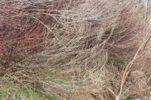

Wisps of the Delaware. All photos © Max Cavitch.
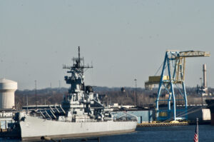
On the water, there’s still plenty of activity—some recreational, but mostly commercial and military. The U.S. Coast Guard has a station nearby, and the U.S. Navy has a major installation another mile or so further south, past the Walt Whitman Bridge. In previous centuries, the Delaware was full of ships carrying cotton, rum, sugar, tobacco, and all the other products of the imperial/slave economies of the 17th, 18th, and 19th centuries.
The Delaware remains the most important commercial waterway in the Northeast. But, in more recent decades, most of what gets shipped up and down the river is oil—millions and millions and millions of gallons of crude oil, totaling 20% of the nation’s annual imports. And, every so often, more than a little of it gets lost in transit. In 1975, for example, over 11,000,000 gallons spilled into the river from a tanker called Corinthos. Ten years later, the tanker Grand Eagle ran aground on the Marcus Hook Bar, spilling just 435,000 gallons. A few years after that, the Presidente Rivera ran aground on Claymont Shoal, spilling slightly more than 300,000 gallons. And in 2004 the Athos 1 lost 265,000 gallons when its hull was punctured by an old, submerged anchor near the Port of Paulsboro.
Along with the oil tankers come flotillas of propane, ethane, butanes, natural gasoline, and coal. Coal barges lose some product in transit as well. Walking along the shoreline on the New Jersey side of the river, just north of the Betsy Ross Bridge, I’ve found lumps of raw anthracite that have fallen off barges and been buffeted and smoothed over the years by river rocks and sand until they wash up on-shore, sable and shiny, like chunks of obsidian.
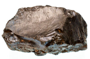
A lump of anthracite, tossed ashore at Palmyra Cove NJ. Photo © Max Cavitch.
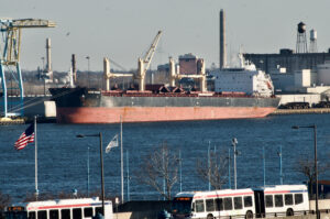
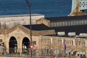
A few miles further south is the Philadelphia Navy Yard. Originally located in the heart of downtown, quite close to my apartment building, it was shifted to its present location in the 19th century, where it remained a major U.S. Naval shipyard until the 1990s. Today, the Navy retains a presence, chiefly for inactive-ship maintenance; but the shipyard complex has also become a large mixed-use campus for private industry. About halfway between Pier 53 and the Navy Yard is the Packer Avenue Marine Terminal of the Port of Philadelphia, which made big news in the summer of 2019 when 16 tons of cocaine—with a street-value of well over $1,000,000,000.00—were seized in one of the largest drug-busts in U.S. history. It seems that crew members on a the container ship MSC Gayane had been receiving bale after bale of cocaine during nighttime rendezvous with smaller ships, while in transit to Philadelphia from Peru.
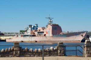
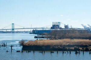
The Navy Yard (l) and, in the distance, the Port of Philadelphia and the Walt Whitman Bridge (r). Both photos © Max Cavitch.
The potency of the drug—not to mention the quantity—overshadow all of the various intoxicating substances (rum, tobacco, sugar, opium, coffee, tea, chocolate) that traveled up and down the Delaware River in previous centuries. And the river itself is different, in a more-than-Lucretian sense: massive dredgers keep shipping lanes free of shoals; petrochemicals are dumped or spilled into it in quantities that would power small countries; the river’s very shape and currents have been altered by feats of human engineering that would boggle even Ben Franklin’s projecting imagination.
Yet to look at the river itself, without the 21st-century frame, is to see something like what Franklin and millions of other Native Americans and European Americans saw too—something like what early poets of the Delaware saw as they watched, like Alfred Billings Street (1811-1881), as it “rolls its broad-spreading volumes,” and followed with their eyes, like Elizabeth Fries Lummis Ellet (1818-1877), its waters’ “glad and onward course.”
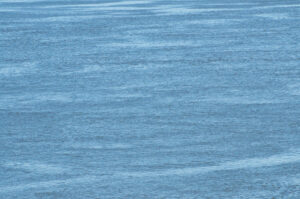
The waters of the Delaware. Photo © Max Cavitch.
U.S. laws, varying from state to state, recognize riparian zones as doctrinally particular, and they codify the specific uses to which they can be put and by whom. This specificity is needed because riparian zones are, by their very nature, zones of transition, perennially subject to dramatic fluctuations of both human and non-human forces, and their lives can be measured in both historical and geological time. As I’ve mentioned, the word “riparian” comes from the Latin word for “riverbank,” but it’s hard not to hear, as well, a false kinship with the word “ripe”—as in “fit” or “ready for action.” One might even fancy a community of like-minded “Riparians,” living alongside the ovenbirds and pigweed flea beetles, testing the precarious limits of everyday life as the matter of both doctrine and necessity we know it so urgently to be.